TORONTO, May 01, 2024 (GLOBE NEWSWIRE) -- BULGOLD Inc. (TSXV: ZLTO) (the “Company” or “BULGOLD”) is pleased to announce that it has sourced historic exploration data relating to the Lutila Gold Project (the “Property”) located in Slovakia. This information has now been validated and incorporated into the Company’s database. The Lutila exploration licence covers an area of 32.2km² and is prospective for quartz-adularia epithermal gold mineralisation.
1. Highlights
- Historic soil sampling has outlined a +7km long, paleo-geothermal system as defined by arsenic and antimony geochemistry which remains open to the south and northwest.1
- Historic rock chip sampling, which is limited to the North East Block, has shown that surface gold grades increase in value (up to 4.44g/t Au) towards lower elevations which is in line with the Company’s current geological model. 1
- Historic exploration drilling, which is also restricted to the North East Block, has shown that there are anomalous gold grades within the rhyolite flow dome complexes and their pyroclastic products on either flank of the Čertov vrch target area; best intersection of 26.2m @ 0.91g/t Au (from 97m). 1
- Rhyolite flow dome complexes define a series of topographic highs (ridgelines) within the licence area which cumulatively extend for approximately 7km; these rhyolite ridges are in turn surrounded by a large (27km²) sinter field.
- The sinter field has not been drill tested for gold mineralisation; it has been extensively drill tested for bentonite (average hole depth 20m). 1
- The Property is located 5km south, along strike and within the same volcanic depression that hosts the historic quartz-adularia Kremnica gold mine (current JORC (2012) mineral resource estimate of 2.7Moz Au2).
- Exploration target: high-grade gold (Au) ± silver (Ag) quartz veins.
Supporting maps can be found at the end of this press release:
Figure 1. The Lutila Exploration Licence – Geology & Arsenic (As) Soil Geochemistry.
Figure 2. The Lutila Exploration Licence – Geology & Antimony (Sb) Soil Geochemistry.
Figure 3. The Lutila Exploration Licence (North East Block) – Geology, Historic Rock & Historic Exploration Drilling.
Quote from the President & CEO, Mr Sean Hasson:
“To see the results of a modern soil sampling survey strongly correlating with the well-mapped geology over +7km highlights the potential size of the Lutila quartz-adularia epithermal system. To also have anomalous gold grades from surface rock chips and historic drilling within the North East Block is a strong endorsement of BULGOLD’s geological model. Lutila is shaping up as what we believe to be a strong early-stage gold project.”
The reader is encouraged to view the Company’s earlier press release “BULGOLD Inc - Acquires the Lutila Gold Project in Slovakia for 100 EUR” dated September 27, 2023, for additional background on the Lutila Gold Project: available at (www.BULGOLD.com).
2. Historic Soil Sampling1
During the early 2000’s, the Lutila exploration area was covered by an extensive soil sampling grid on a nominal east-west, 200m x 40m grid spacing. Some 3,560 soil samples were collected and subsequently assayed for gold (Au), silver (Ag), arsenic (As), antimony (Sb), tellurium (Te), mercury (Hg), thallium (Tl) and bismuth (Bi).
Following the Company’s review of the historic soil data it became clear that both arsenic and antimony provide compelling evidence for an extensive paleo-geothermal system within the Lutila exploration area. Mercury and thallium soil data provide some support for selective areas within the exploration area, while gold, silver, tellurium and bismuth are of a very low overall tenor, which is to be expected given the level of exposure that the current land surface represents i.e. the Sinter Field reflects the Miocene paleosurface while the North East Block probably represents a surface approximately 50-100m below the same Miocene paleosurface (as determined from the local topographic high, Čertov vrch (748mRL)).
Commonly, arsenic and antimony geochemical levels are elevated within the upper levels of quartz-adularia, low-sulfidation epithermal systems. The Lutila Gold Project is no exception, with extensive As and Sb anomalism defined over approximately 7km within the rhyolite flow dome complexes and their pyroclastic products. Within the North East Block, where erosion has removed the sinters and exposed silicified rhyolites ± chalcedonic veins, the As and Sb soil geochemistry is broad and pervasive and correlates very well with mapped geology. Within the Sinter Field the As and Sb geochemistry drapes the western and eastern flanks of the prominent 6km long ridgeline (“Rhyolite Ridge”) strongly suggesting that deeply derived, near neutral pH, alkali chloride waters have permeated through the rhyolite dome complexes and their pyroclastic products as evidenced by the large volume of sinter formation at various topographic levels. The historic soil sampling also suggests that there is a thin, post-mineral rhyolite flow dome complex located on the central portion of the ridgeline where soil geochemistry provides a very muted response (see Figures 1 & 2).
3. Historic Rock Sampling1
Historic rock chip sampling was confined to the North East Block only, there have reportedly been no rock chip samples taken from within the Sinter Field.
A total of 80 rock chip samples were taken within the North East Block (including 4 samples taken by the Company as part of its due diligence) and assayed for gold and silver, together with multi-element data for various elements. The Company’s review of this data strongly indicates that there is a topographic control on the gold data in that all rock samples located above the 600mRL return an average gold grade of <0.001g/t Au (n = 45), while all rock samples below the 600mRL return an average gold grade of 0.68g/t Au (n = 35). Base metal content of the rock samples for copper, lead and zinc are very low and average <2ppm, <13ppm and <19ppm respectively (see Table 1 and Figure 3).
Table 1. North East Block: All Rock Chip Samples >0.1g/t Au
| SAMPLEID | X_UTM34N | Y_UTM34N | Z_UTM34N | Au_BEST_ppm | Ag_BEST_ppm | As_BEST_ppm | Sb_BEST_ppm |
| 5072 | 345737 | 5391390 | 519 | 4.44 | 36.8 | 78 | 444 |
| 5071 | 345731 | 5391370 | 508 | 3.60 | 33.1 | 49 | 562 |
| 5070 | 345728 | 5391360 | 508 | 2.89 | 22 | 69 | 512 |
| 5073 | 345727 | 5391405 | 519 | 2.63 | 26.5 | 111 | 264 |
| 5074 | 345744 | 5391434 | 528 | 1.37 | 22.8 | 60 | 439 |
| 5076 | 345740 | 5391520 | 542 | 1.06 | 12.5 | 93 | 568 |
| 5075 | 345737 | 5391441 | 532 | 1.04 | 6.8 | 21 | 277 |
| SAMPLEID | X_UTM34N | Y_UTM34N | Z_UTM34N | Au_BEST_ppm | Ag_BEST_ppm | As_BEST_ppm | Sb_BEST_ppm |
| 45045 | 344520 | 5392500 | 545 | 0.81 | 5.42 | 50 | 10 |
| 45047 | 344540 | 5392507 | 550 | 0.76 | 6.78 | 151 | 14 |
| 5077 | 345751 | 5391583 | 532 | 0.64 | 15.5 | 56 | 373 |
| 45048 | 344580 | 5392505 | 562 | 0.62 | 2.53 | 438 | 61 |
| 5080 | 345781 | 5392383 | 539 | 0.60 | 4.7 | 335 | 104 |
| 5062 | 345845 | 5390833 | 440 | 0.57 | 2.1 | 666 | 2019 |
| 5113 | 344523 | 5392485 | 549 | 0.47 | 4.5 | 167 | 205 |
| 5078 | 345748 | 5391594 | 527 | 0.35 | 5.2 | 117 | 164 |
| 45046 | 344530 | 5392515 | 550 | 0.34 | 1.7 | 74 | 10 |
| 5065 | 345829 | 5390811 | 439 | 0.29 | 2.1 | 1566 | 223 |
| 5079 | 345787 | 5392400 | 543 | 0.28 | 2.5 | 540 | 94 |
| 5063 | 345829 | 5390811 | 439 | 0.25 | 1.2 | 759 | 372 |
| 5069 | 345725 | 5391352 | 508 | 0.23 | 1.4 | 507 | 374 |
| 5115 | 344441 | 5392502 | 531 | 0.22 | 1 | 465 | 456 |
| 5124 | 344777 | 5392017 | 557 | 0.17 | <1 | 183 | 184 |
| 5114 | 344458 | 5392506 | 531 | 0.12 | 1 | 270 | 216 |
4. Historic Exploration Drilling1
Historic exploration diamond drilling was confined to the North East Block only, the Sinter Field has not been drill tested for gold mineralisation; it has been extensively drill tested for bentonite (average hole depth 20m).
The Company has divided the historic exploration drilling into two separate phases:
Historic Drill Holes: 10 diamond drill holes were completed into the eastern flank of the North East Block for a total of 1,984.3m during the 1990’s. The majority of these drill holes were drilled horizontally into the side of the hill above the village of Bartošova Lehôtka. No assay data is available for these drill holes; however, geology information is available. Of particular interest was drill hole VKS-4, which was one of the few angle holes drilled, which intercepted minor rhyolite from 0-10m after which andesite volcanic rocks were intersected to end of hole and therefore verifying that andesite volcanic rocks are present beneath the rhyolite flow dome complexes in a similar stratigraphic setting to the nearby Kremnica gold mine (see Table 2 & Figure 3).
Modern Drill Holes: 21 diamond drill holes for a total of 4,791.1m were completed within the Čertov vrch target area. The drilling programme was completed by the Tournigan Gold Corporation (a delisted TSXV company) during the period 2004-2006 (see Table 3 & Figure 3):
- Čertov vrch prospect area located on and around the topographic high (748mRL) and the northernmost cluster of drill holes within the North East Block; 8 drill holes for 2,287m.
- Kopernica Structure prospect area located 900m southwest of the Čertov vrch prospect area; 6 drill holes for 826.2m.
- Bartošova Lehôtka prospect area located 2km south-southeast of the Čertov vrch prospect area; 3 drill holes for 826.2m (KG-BL-1 & KG-BL-2 are annotated in Figure 3).
- Čertov vrch East prospect area located 1.15km southeast of the Čertov vrch prospect area; 4 drill holes for 907.1m.
Assay data is unavailable for the majority of drill holes and some geology information is available; however, it is believed that drilling in the Čertov vrch and Čertov vrch East prospect areas resulted in no gold mineralisation being recorded. The Čertov vrch drilling did, however, intersect andesite volcanic rocks approximately 150m beneath the topographic high at 748mRL. The Kopernica Structure drilling was apparently a combined project sterilisation/exploration programme and minor anomalous gold intervals were recorded within rhyolite pyroclastic rocks. The Bartošova Lehôtka prospect area also recorded some gold anomalous intervals within the rhyolite flow dome complex and their pyroclastic products and represent the drill holes collared at some of the lowest elevations to date within the Lutila exploration area.
Gold anomalous intervals from the Bartošova Lehôtka and Kopernica Structure prospect areas are outlined below:
Bartošova Lehôtka:
KG-BL-1*
- 5.3m @ 1.26g/t Au (from 84.4m)
- 26.2m @ 0.91g/t Au (from 97m)
- 5.1m @ 0.63g/t Au (from 138m)
KG-BL-2*
- 24.3m @ 0.76g/t Au (from 51.7m)
- 11.7m @ 0.94g/t Au (from 156.3m)
*2m minimum composite length, 2m maximum internal dilution, 0.5g/t Au cut-off.
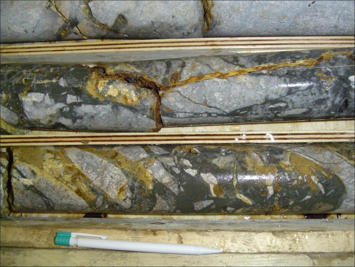
Figure 4: Strongly silicified rhyolite tuff, brecciated, with dark chalcedony and stibnite stockwork infill plus limonite (orange) after sulfides (KG-BL-1: 104.1-105.5m; 2.98g/t Au)
Kopernica Structure:
KG-KP-2a**
- 12.8m @ 0.26g/t Au (from 16.2m)
KG-KP-3**
- 6m @ 0.29g/t Au (from 1m)
KG-KP-5**
- 3.1m @ 0.15g/t Au (from 86.9m)
KG-KP-5a**
- 22.4m @ 0.34g/t Au (from 85.6m)
**2m minimum composite length, 2m maximum internal dilution, 0.1g/t Au cut-off; the Company considers this to represent a ‘geological cut-off’ which shows that gold is present in rhyolite volcanic rocks at anomalous values.
Table 2: Historic Drill Hole Information
| HOLEID | X_UTM34N | Y_UTM34N | Z_UTM34N | Z_EOH | DEPTH | DIP | AZIMUTH | PROSPECT AREA |
| VKS1 | 345922 | 5390876 | 422 | 249 | 200 | -60 | 100 | Bartošova Lehôtka |
| VKS2 | 345922 | 5390876 | 422 | 386 | 51 | -45 | 280 | Bartošova Lehôtka |
| VKS3 | 345784 | 5390960 | 427 | 356 | 100.5 | -45 | 90 | Bartošova Lehôtka |
| VKS4 | 345941 | 5391767 | 433 | 290 | 209.3 | -43 | 260 | Bartošova Lehôtka |
| VKS5 | 345996 | 5391498 | 418 | 418 | 255.5 | 0 | 270 | Bartošova Lehôtka |
| VKS6 | 346022 | 5393123 | 443 | 443 | 300 | 0 | 270 | Bartošova Lehôtka |
| VKS7 | 346159 | 5392284 | 419 | 419 | 300 | 0 | 270 | Bartošova Lehôtka |
| VKS7a | 346159 | 5392284 | 419 | 419 | 71 | 0 | 270 | Bartošova Lehôtka |
| VKS8 | 345890 | 5390549 | 396 | 396 | 197 | 0 | 270 | Bartošova Lehôtka |
| VKS9 | 346052 | 5392841 | 445 | 445 | 300 | 0 | 270 | Bartošova Lehôtka |
Table 3: Modern Drill Hole Information
| HOLEID | X_UTM34N | Y_UTM34N | Z_UTM34N | Z_EOH | DEPTH | DIP | AZIMUTH | PROSPECT AREA |
| KG-BL-1 | 345791 | 5391545 | 519 | 346 | 200 | -60 | 240 | Bartošova Lehôtka |
| KG-BL-2 | 345684 | 5391551 | 539 | 383 | 220.8 | -45 | 120 | Bartošova Lehôtka |
| KG-BL-3 | 345891 | 5391387 | 483 | 236 | 350 | -45 | 300 | Bartošova Lehôtka |
| KG-BS-1 | 345307 | 5392660 | 586 | 409 | 250 | -45 | 270 | Čertov vrch |
| KG-CV-1 | 344949 | 5393398 | 753 | 567 | 186 | -90 | 360 | Čertov vrch |
| KG-CV-2 | 344915 | 5393284 | 758 | 578 | 208 | -60 | 320 | Čertov vrch |
| HOLEID | X_UTM34N | Y_UTM34N | Z_UTM34N | Z_EOH | DEPTH | DIP | AZIMUTH | PROSPECT AREA |
| KG-CV-3 | 344992 | 5393262 | 760 | 500 | 300.3 | -60 | 325 | Čertov vrch |
| KG-CV-4 | 344872 | 5393401 | 726 | 327 | 487.4 | -55 | 120 | Čertov vrch |
| KG-CV-5 | 344878 | 5393497 | 719 | 488 | 301.3 | -50 | 145 | Čertov vrch |
| KG-CV-6 | 345212 | 5393279 | 730 | 495 | 332 | -45 | 325 | Čertov vrch |
| KG-CV-7 | 345218 | 5393373 | 736 | 544 | 222 | -60 | 325 | Čertov vrch |
| KG-KP-1 | 344666 | 5392370 | 592 | 500 | 130 | -45 | 320 | Kopernica Structure |
| KG-KP-2 | 344643 | 5392565 | 582 | 490 | 130 | -45 | 335 | Kopernica Structure |
| KG-KP-2a | 344673 | 5392593 | 596 | 507 | 98.5 | -65 | 285 | Kopernica Structure |
| KG-KP-3 | 344588 | 5392645 | 596 | 472 | 175 | -45 | 100 | Kopernica Structure |
| KG-KP-5 | 344730 | 5392665 | 617 | 521 | 135.4 | -45 | 280 | Kopernica Structure |
| KG-KP-5a | 344729 | 5392666 | 617 | 465 | 157.3 | -75 | 280 | Kopernica Structure |
| KG-VKS-7 | 345802 | 5392412 | 543 | 413 | 158.1 | -55 | 220 | Čertov vrch East |
| KG-VKS-9 | 345966 | 5392739 | 488 | 332 | 220 | -45 | 320 | Čertov vrch East |
| KG-VKS-9a | 345971 | 5392735 | 488 | 311 | 251 | -45 | 90 | Čertov vrch East |
| KG-VKS-9b | 345970 | 5392736 | 488 | 247 | 278 | -60 | 90 | Čertov vrch East |
5. Discussion
Historic soil sampling has outlined a significant, +7km long, paleo-geothermal system as defined by arsenic and antimony geochemistry. Historic rock chip sampling, which is limited to the North East Block, has shown that surface gold grades increase in value towards lower elevations, which is in line with the Company’s current geological model. Historic exploration drilling, which is also restricted to the North East Block, has shown that there are anomalous gold grades within the rhyolite flow dome complexes and their pyroclastic products on either flank of the Čertov vrch target area which is centred on the Čertov vrch peak (748mRL).
At the nearby Kremnica gold mine, which is hosted in andesite volcanic rocks, rhyolite dykes are intimately associated with and often well mineralised where they are cross-cut, or run parallel to quartz-adularia veins, thus indicating that extrusive rhyolite volcanism was likely a pre-(syn?) mineral event. The historic exploration drilling has indicated that andesite volcanic rocks are present below the exposed rhyolite flow dome complexes and their associated pyroclastic products within the area of the North East Block and it is likely that andesite volcanic rocks are present beneath the rhyolite stratigraphy currently exposed within the Sinter Field.
The Company believes that the Lutila Gold Project reflects a continuation of the same volcanic depression (which hosts the Kremnica gold mine), which has been downfaulted, creating a preserved graben of rhyolite flow domes complexes and their pyroclastic products together with a very large sinter field.
This review of the historic exploration data, from primarily within the North East Block, taken together with the extensive Sinter Field, which reflects the position of the Miocene paleosurface and is an indication of boiling at depth within an epithermal system which, if present, is preserved from erosion, would tend to strongly support the Company’s conceptual exploration model, which is outlined below:
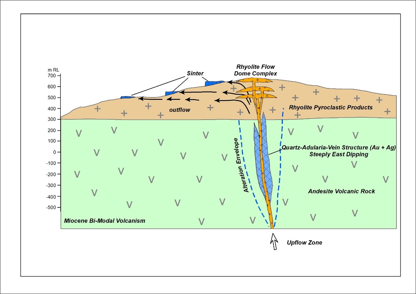
Figure 5: The BULGOLD conceptual exploration model for the Lutila Gold Project.
6. Next Steps
- Complete the procedure for obtaining permission for the Company’s inaugural drilling programme from Slovak authorities and commence drilling on the Lutila Gold Project.
- Continue to conduct meetings with local and national stakeholders.
7. About the Slovak Republic
- EU and NATO member since 2004.
- Eurozone member since 2009.
- Established mining industry, clearly defined mining legislation.
- No restrictions on foreign ownership.
- 21% corporate tax rate.
- 5% NSR for gold and silver.
- The use of cyanide for extractive purposes has been prohibited since 2014.
- Low-cost profiles, skilled local workforce.
- Exploration licences can be held for a 10-year period (4+4+2).
About BULGOLD Inc.
BULGOLD is a gold exploration company focused on the exploration and development of mineral exploration projects in Central and Eastern Europe. The Company controls 100% of three quality quartz-adularia epithermal gold projects located in the Slovakian and Bulgarian portions of the Western Tethyan Belt: the Lutila Gold Project, the Kostilkovo Gold Project and the Kutel Gold Project. Management of the Company believes that its assets show potential for high-grade, good-metallurgy, low-sulfidation epithermal gold mineralisation.
- Historic Sampling and Drilling Data and Information
The historical sampling and drilling data and information disclosed in this press release is related to historical exploration results. The reader is cautioned that the historical sampling and drilling data and information are based on prior data and reports previously prepared by third parties without the involvement of the Company. Information has been sourced from the Slovak Geological Survey in reports 83971 (December 1997) and 92416 (February 2013). BULGOLD has not undertaken any independent investigation of the historical sampling and drilling data and information, nor has it independently analysed the results of the historical sampling and drilling exploration work in order to verify the results. The reader is cautioned not to treat them, or any part of them, as current and that a qualified person has not done sufficient work to verify the results and that they may not form a reliable guide to future results. No independent quality assurance/quality control protocols are known for these historic samples and drill holes and therefore the analytical results, data and information may be unreliable. BULGOLD considers the historical sample and drill data and information to be relevant as BULGOLD is using this data and information, in conjunction with the sampling conducted by BULGOLD, as a guide to plan its exploration program for the Lutila Gold Project. BULGOLD’s current exploration work includes verification of the historical data and information through further exploration.
Quality Assurance/Quality Control
With respect to sample information in this new release that was prepared by the Company and is not historic sampling and drilling information, rock samples are shipped to SGS Bor, Serbia, which is an independent laboratory. Quality control samples, comprising certified reference materials, blanks, and field duplicates, are inserted into each batch of samples and locations for crushed duplicates and pulp replicates are specified. At the SGS Bor laboratory, the submitted rock samples are dried at 105°C for a minimum of 12 hours, and then jaw crushed to about 80% passing 4mm. Sample preparation duplicates are created by riffle splitting crushed samples on a 1 in 20 basis. Larger samples are riffle split prior to pulverizing, whereas smaller samples are pulverized entirely. Pulverizing specifications are 90% passing 75 microns. Gold analyses are done using a conventional 50-gram fire assay and AAS finish.
On December 31, 2023, BULGOLD had approximately $2.0 million in its treasury and BULGOLD’s issued and outstanding shares were 27,597,928 of which approximately 39.54% were held by Founders, Directors and Management. Additional information about the Company is available on BULGOLD’s website (www.BULGOLD.com) and on SEDAR+ (www.sedarplus.ca).
Qualified Person
The scientific and technical information in this news release was reviewed and approved by Mr Sean Hasson, a Qualified Person as defined by National Instrument 43-101 and President and Chief Executive Officer to the Company.
For further information, please contact:
BULGOLD Inc.
Sean Hasson, President and Chief Executive Officer
Telephone: +359 2 989 2361
Email: information@BULGOLD.com
Website: www.BULGOLD.com
Neither TSX Venture Exchange nor its Regulation Services Provider (as that term is defined in the policies of the TSX Venture Exchange) accepts responsibility for the adequacy or accuracy of this release.
Cautionary Statement Regarding Forward-Looking Information
This press release contains forward‐looking statements and forward‐looking information within the meaning of applicable securities laws (collectively, “forward-looking statements”). These statements relate to future events or future performance and include statements relating to the Lutila Gold Project and the status of the Lutila Gold Project as a strong early-stage gold project in Europe, the Kremnica gold mine, the reason for the Kremnica gold mine being exploited over a long period of time, the Lutila Gold Project reflecting a continuation of the same Kremnica volcanics, the Company’s conceptual exploration model for the Lutila Gold Project, the potential of the Lutila Gold Project to benefit the Company’s stakeholders, the mineralised inventory within the Kremnica deposit through time, the exploration plans of the Company and the timing thereof. All statements other than statements of historical fact may be forward‐looking statements or information. The forward‐looking statements and information are based on certain key expectations and assumptions made by management of the Company. Although management of the Company believes that the expectations and assumptions on which such forward-looking statements and information are based are reasonable, undue reliance should not be placed on the forward‐looking statements and information since no assurance can be given that they will prove to be correct.
Forward-looking statements and information are provided for the purpose of providing information about the current expectations and plans of management of the Company relating to the future. Readers are cautioned that reliance on such statements and information may not be appropriate for other purposes, such as making investment decisions. Since forward‐looking statements and information address future events and conditions, by their very nature they involve inherent risks and uncertainties. Actual results could differ materially from those currently anticipated due to a number of factors and risks, including the inherent uncertainty of mineral exploration; risks related to title to mineral properties; and credit, market, currency, operational, commodity, geopolitical, liquidity and funding risks generally, including changes in economic conditions, interest rates or tax rates and general market and economic conditions. Accordingly, readers should not place undue reliance on the forward‐looking statements and information contained in this press release. Readers are cautioned that the foregoing list of factors is not exhaustive. The forward‐looking statements and information contained in this press release are made as of the date hereof and no undertaking is given to update publicly or revise any forward‐looking statements or information, whether as a result of new information, future events or otherwise, unless so required by applicable securities laws. The forward-looking statements and information contained in this press release are expressly qualified by this cautionary statement.
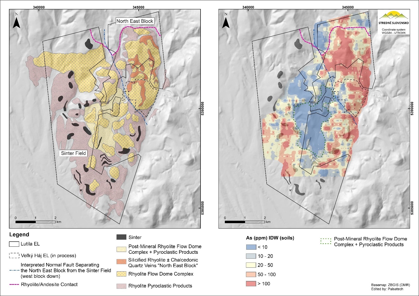
Figure 1. The Lutila Exploration Licence – Geology & Arsenic (As) Soil Geochemistry.
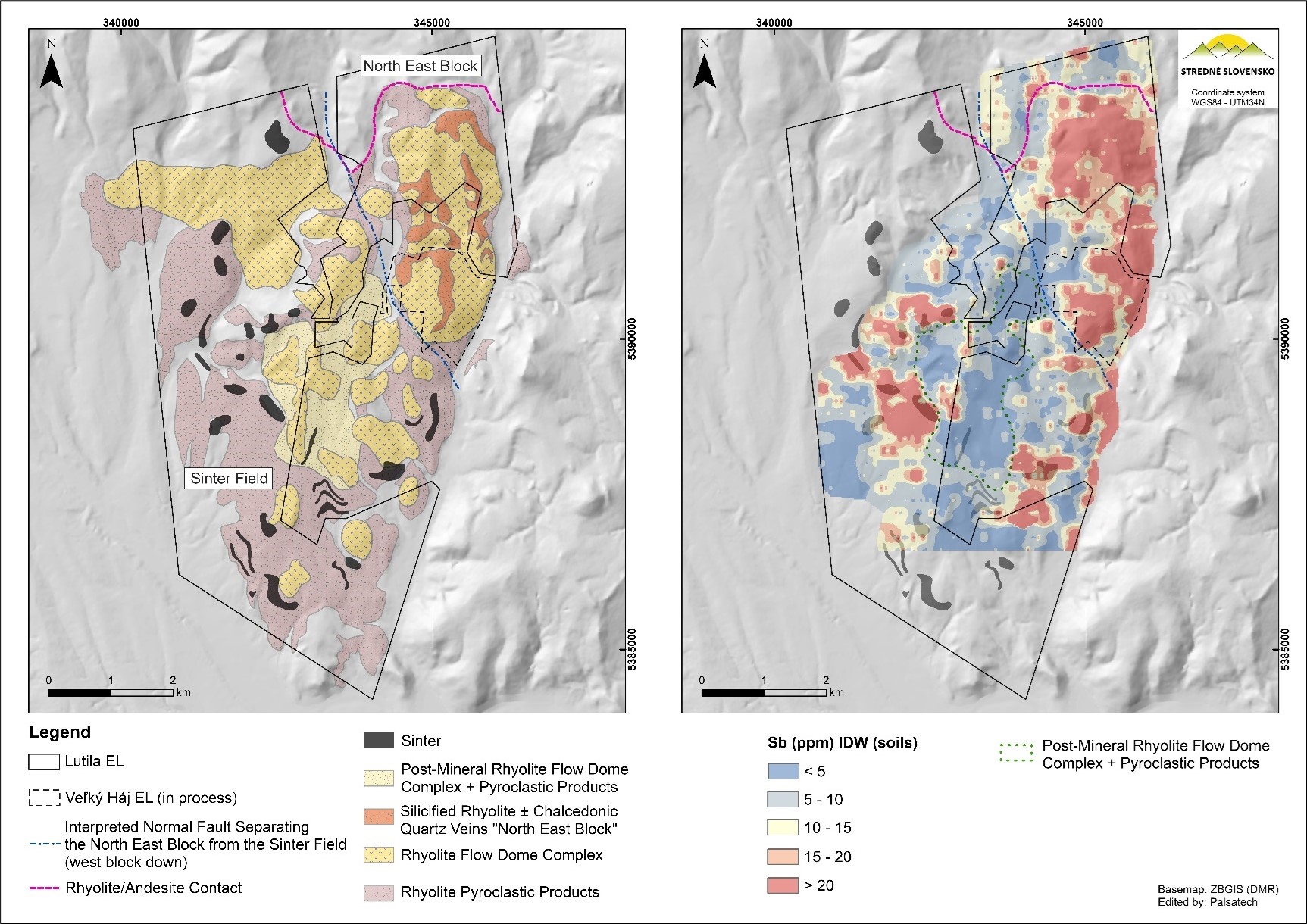
Figure 2. The Lutila Exploration Licence – Geology & Antimony (Sb) Soil Geochemistry.
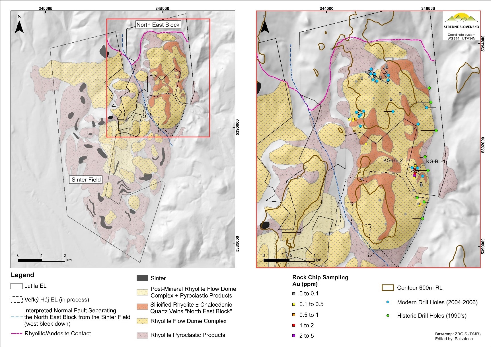
Figure 3. The Lutila Exploration Licence (North East Block) – Geology, Historic Rock & Historic Exploration Drilling.
Figures 4 and 5 accompanying this announcement are available at:
https://www.globenewswire.com/NewsRoom/AttachmentNg/b08c54bf-90bb-43d8-829c-dae0439c3689
https://www.globenewswire.com/NewsRoom/AttachmentNg/4845fce4-30ee-4d82-956f-16bd0514feba
